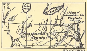
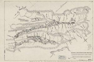
Land Grants in Augusta County, VA
The early system for granting small tracts of land did not accomplish the goal of rapid land occupation. The outcome was the implementation of a Land Grant Model whereby land speculators would receive land from the Crown with conditions that the recipient of the Land Grant would be obligated to recruit a certain number of settlers, or survey the land and record the survey.
The sale of land with a recorded survey was the financial reward for both the Land Grant recipient and the Crown. This opportunity has been described as the “Great Virginia Land Grab.”
At the dawn of the 18th century, Virginians in eastern Virginia were no longer just colonists. They had endured for almost one hundred years and were now prosperous with a defined government and little threat from Native Americans. A political culture had developed.
The office of the Secretary of the Colony would only issue patents after all steps in the land patent process were completed. First, the patentee was required to appear before a county court and present proof of importation and land assignment.
A certificate of importation rights would then be issued by the courts and presented to the office of the Secretary of the Colony in Williamsburg. The Secretary of the Colony would then issue a “right” that, when presented to a county surveyor, authorized him to survey the tract claimed by the patentee.
Once the survey was completed, it and all supporting papers were returned to the office of the Secretary of the Colony, and two copies of the patent were made. One copy was signed by the governor, sealed, and delivered to the patentee, and the other was retained by the Secretary of the Colony.
The Patentee was also required to provide a copy of the survey and supporting documents to the local court house for recording. Augusta County began recording surveys in 1742. By the mid 18th century the Augusta County Court House became very efficient at the recording of surveys, thus, as a matter of convenience, the recordings with the Office of the Secretary of the Colony became very relaxed.
The recording of land patents was not without problems. Squatting upon unoccupied lands in the “back country” continued. By 1730, hundreds of uninvited settler families squatted on land west of the Blue Ridge Mountains.
This practice continued even after the large land grants were awarded in Augusta County, beginning in 1736. Disputes were common place, and many of these disputes were not resolved until late in the 19th century. On the positive side, the owners of the large Land Grants often settled with the squatter settlers for small fees, thus, gaining credit of settling a family on their land grant. This practice helped them obtain the number of settlers required as a condition for their land grant. Such was the case with the Walker Family that settled on Walkers Creek.
With approval from the British Crown, Colonial Virginia Lieutenant Governor Gooch, his successor, Lieutenant Governor Dinwiddie, and others, responded to the request made by affluent colonists and issued large Land Grants. The migration of Germans and Scotch-Irish to Augusta County was great, and the well-connected Virginians became land speculators by using their influence to stay one step ahead of these settlers.
The first Land Grant issued in Augusta County was the Manor of Beverley Land Grant issued to Colonel William Beverley. The land was granted through the Governor’s Council and recorded by the office of the Secretary of the Colony.
The grant was issued in 1736 and when the survey was complete, the patent consisted of 118,491 acres in Eastern Augusta County. The early surveyor for the Manor of Beverley Land Grant was John Preston (d. March, 1748). This land patent was known as the Manor of Beverley.
In 1739 Benjamin Borden, a New Jersey Quaker, received a large land grant to the west and south of the Manor of Beverley patent. Under the terms of
his Land Grant, Borden would receive 1,000 acres for every settler he located on his tract. The total patent turned out to be 92,000 acres. James Wood and John McDowell were the surveyors who defined many of the boundaries of the patents for the Borden Land Grant. McDowell received a large tract of land for his work.
Borden had lived in the northern Shenandoah Valley since 1734 and was acquainted with Governor Gooch. He was an explorer by nature and was familiar with the land lying beyond the Manor of Beverley
It has long been reported that he obtained this large grant by winning the favor of Lieutenant Governor William Gooch through the gift of a buffalo calf.
In 1743 John Lewis and James Patton obtained a grant for 10,500 acres on Calf Pasture River in western Augusta County. William Preston surveyed many of the patents for this land grants.
In 1745, the Woods River Company was awarded 100,000 acres in southeast Augusta County. The Woods River Company was owned by John Patton, John Buchanan, John Preston, and Benjamin Waller and his family.
The group was struggling to get their Land Grant until Benjamin became a partner. He was an attorney in Williamsburg, Virginia, and served as the Clerk of the Governor’s Council.
In 1748, they established the settlement of Blacksburg. John Buchanan provided the surveys for the patents in the Woods River Land Grant
These four Land Grants and earlier individual settler patents were important and proved successful for transferring land to settlers moving into eastern Augusta County; however, these land grants only accounted for a small portion of the vast amounts of unclaimed land in Augusta County.
Thousands of square miles of land in Western Augusta County, that Virginia claimed based on earlier proclamations by the Crown, remained available for settlement.
The outcome was that large groups of influential Virginians formed land companies and petitioned for large tracts of land that reached to the relatively unknown western boundaries of Augusta County.
Frontiersmen and traders were frequenting the vast land in Western Augusta County to trade, explore, and interact with Native Americans living on this land.
France maintained a presence along the Ohio River, and also claimed that much of the land in Western Augusta County belonged to France.
Frontiersmen, like William Trent and Christopher Gist, reported that the Allegheny Mountains and the Ohio River, with its tributaries, provided a natural division within the boundaries of Augusta County.
Two important land companies emerged in the late 1740s. First there was the Ohio Company which was followed closely by the Loyal Company of Virginia.
Both of these land companies petitioned the Crown and received very large land grants west of the Allegheny Mountains in Augusta County.
In 1748, Lt. Governor Dinwiddie joined with Lawrence Washington, Augustine Washington, and Thomas Lee to form the Ohio Company, a Virginia land company.
Lt. Governor Dinwiddie, while still governor of Virginia, convinced the British Crown to award 500,000 acres of land in Augusta County (Ohio) to the Ohio Company.
Owners of the Ohio Company were well aware of the value of the land to the west of the Monongahela River and north of the Ohio River in the Ohio Country.
Governor Dinwiddie was very aware that the French had also claimed the land in the Ohio Country.
Explorers and traders, such as William Trent, had traveled and traded among the Native Americans in the Ohio Valley along the Ohio River (Ohio means “Great River” in Iroquois language).
Trent was from Pennsylvania; however, he often represented Virginia in his exploration of the Forks of the Ohio (present day Pittsburgh) and beyond.
In 1744, Trent made large land purchases from Native Americans in the Ohio Country along the Ohio River.
An entrepreneurial spirit had also developed and was driven by the dream of land speculation and wealth. Political favors and relationships, fueled by greed, often resulted in complex partnerships being granted large tracts of land in Augusta County. These land grants were made to land speculators that would encourage immigrants from the colonies and even from Europe to purchase and settle on tracts of land owned by these land holders.
In Virginia, the office of the Secretary of the Colony retained jurisdiction over the process of issuing large land grants to individuals or groups. The individual patents for the land were sold by the owners of the land grants to settlers, and were also recorded by the Secretary of the Colony. This jurisdiction remained in place until after the Revolutionary War.