Surveying
Surveying was an important skill throughout Virginia and especially in Augusta County where the boundaries of property for the land grants and individual land patents were decided. During the 18th century, a gentleman could achieve several different titles such as a Burgess, Justice, Sheriff, or County Surveyor.
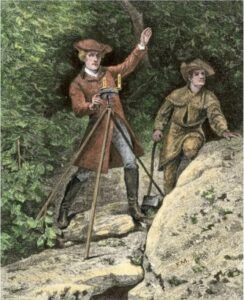
The County Surveyor was perceived as being among the most prestigious appointments in the 18th century society. They were well trained and were appointed to the position of County Surveyor or Deputy County Surveyor by the Office of the Surveyor General for the Colony of Virginia. This office was administered by the College of William & Mary from 1693 until the Revolution. Surveyors were frequent visitors to the county courts; and they received the order to survey from the Secretary of the Colony. Perhaps more important was the fact that these surveyors frequented the frontier as leaders of survey crews. This role provided a exciting element to their work. As they traveled to the frontier, they often became the settlers’ only contact with a colonial official.
Surveyors were either trained through apprenticeships or by attending William and Mary College. In many cases these surveyors received both types of training. Young men could improve their skill by reading books such as John Gibson’s Treatise on Surveying and John Love’s GEODÆSIA, however hands-on practice was essential and training at William and Mary College was important for an appointment.
The surveyor was responsible for transferring land from the Crown to private ownership. The process started with a settler’s selection of a tract. One of the perks for being an appointed surveyor was the ability to acquire land. They knew the land and had the connections to get land patents for themselves (which were often at no cost from the Crown), or from the companies that owned land grants. The surveyor’s primary survey tools included a log book, pencils, a surveyor’s ax, a surveyor’s compass, a surveyor’s chain (called the “Gunter’s Chain”) and a set of plotting instruments. Surveyors also carried with them personal items such as a longrifle, a pipe tomahawk, a possible pouch, a knife, and a powder horn.
There were many skilled surveyors working in Augusta County in the 18th century. John Patton, John Buchanan, John Preston, Benjamin Waller, and Daniel Smith were all surveyors. Many of the surveyors in Augusta County were also awarded important land grants. Being a surveyor was an important position in Augusta County as these men were often the decision makers in deciding land holdings.
By 1740, much of Virginia east of the Allegheny Mountains was inhabited by families. Native American raids had diminished. By 1750, many families had migrated to the Valley of Virginia section of Augusta County. Some families had migrated to and even beyond the Allegheny Mountains into the Ohio Country. On February 25th, 1752, the Virginia House of Burgesses passed an act to encourage persons to settle in Augusta County.
Early settlement of these lands by recruited settlers was not well received by some Native Americans, or by the French military who had officially claimed the Ohio River and surrounding lands for France. This dispute escalated among Native Americans, France, England, and the English colonials as land began to be surveyed. Native Americans were divided between the British and the French as to their allegiance. That allegiance changed from day to day.
Page developed by Gordon Barlow gordon@amaty.com